Wednesday, September 4, 2019

Himalayas

Himalayas
Mount Everest as seen from Drukair2 PLW edit.jpg
Aerial view of Mount Everest and surrounding landscape
Highest point
PeakMount Everest (Nepal and China)
Elevation8,848 m (29,029 ft)
Coordinates27°59′N 86°55′ECoordinates: 27°59′N 86°55′E 
Dimensions
Length2,400 km (1,500 mi)
Naming
Native nameSagarmatha
Geography
Himalayas Map.png
The general location of the Himalayas mountain range (this map has the Hindu Kush in the Himalaya, not normally regarded as part of the core Himalayas).
Countries
ContinentAsia
The Himalayas, or Himalaya (/ˌhɪməˈleɪə, hɪˈmɑːləjə/), is a mountain range in Asia, separating the plains of the Indian subcontinent from the Tibetan Plateau. The range has many of the Earth's highest peaks, including the highest, Mount Everest, Nepal. The Himalayas include over fifty mountains exceeding 7,200 m (23,600 ft) in elevation, including ten of the fourteen 8,000-metre peaks. By contrast, the highest peak outside Asia (Aconcagua, in the Andes) is 6,961 m (22,838 ft) tall.[1]
Lifted by the subduction of the Indian tectonic plate under the Eurasian Plate, the Himalayan mountain range runs west-northwest to east-southeast in an arc 2,400 km (1,500 mi) long.[2] Its western anchor, Nanga Parbat, lies just south of the northernmost bend of Indus river. Its eastern anchor, Namcha Barwa, is just west of the great bend of the Yarlung Tsangpo River (upper stream of the Brahmaputra River). The Himalayan range is bordered on the northwest by the Karakoram and the Hindu Kush ranges. To the north, the chain is separated from the Tibetan Plateau by a 50–60 km (31–37 mi) wide tectonic valley called the Indus-Tsangpo Suture.[3] Towards the south the arc of the Himalaya is ringed by the very low Indo-Gangetic Plain.[4] The range varies in width from 350 km (220 mi) in the west (Pakistan) to 150 km (93 mi) in the east (Arunachal Pradesh).[5] The Himalayas are distinct from the other great ranges of central Asia, although sometimes the term 'Himalaya' (or 'Greater Himalaya') is loosely used to include the Karakoram and some of the other ranges.
The Himalayas are inhabited by 52.7 million people,[5] and are spread across five countries: Bhutan, China, India, Nepal and Pakistan. The Hindu Kush range in Afghanistan[6] and Hkakabo Razi in Myanmar are normally not included, but they are both (with the addition of Bangladesh) part of the greater Hindu Kush Himalayan (HKH) river system;[7] some of the world's major rivers – the Indus, the Ganges and the Tsangpo-Brahmaputra – rise in the Himalayas, and their combined drainage basin is home to roughly 600 million people. The Himalayas have a profound effect on the climate of the region, helping to keep the monsoon rains on the Indian plain and limiting rainfall on the Tibetan plateau. The Himalayas have profoundly shaped the cultures of the Indian subcontinent, with many Himalayan peaks considered sacred in Hinduism and Buddhism.

Name

The name of the range derives from the Sanskrit Himā-laya (हिमालय, "Abode of Snow"), from himá (हिम, "snow") and ā-laya (आलय, "receptacle, dwelling").[8] They are now known as the "Himalaya Mountains", usually shortened to the "Himalayas". Formerly, they were described in the singular as the Himalaya. This was also previously transcribed Himmaleh, as in Emily Dickinson's poetry[9] and Henry David Thoreau's essays.[10]
The mountains are known as the Himālaya in Nepali and Hindi (both written हिमालय), the Himalaya (ཧི་མ་ལ་ཡ་) or 'The Land of Snow' (གངས་ཅན་ལྗོངས་) in Tibetan, the Himāliyah Mountain Range (Urdu: سلسلہ کوہ ہمالیہ‎) in Urdu and the Ximalaya Mountain Range (Chinese: 喜马拉雅山脉; pinyin: Xǐmǎlāyǎ Shānmài) in Chinese.

Geography and key features

A satellite image showing the arc of the Himalayas
In the middle of the great curve of the Himalayan mountains lie the 8,000 m (26,000 ft) peaks of Dhaulagiri and Annapurna in Nepal, separated by the Kali Gandaki Gorge. The gorge splits the Himalayas into Western and Eastern sections both ecologically and orographically – the pass at the head of the Kali Gandaki, the Kora La is the lowest point on the ridgeline between Everest and K2(the highest peak of Pakistan ). To the east of Annapurna are the 8,000 m (5.0 mi) peaks of Manaslu and across the border in Tibet, Shishapangma. To the south of these lies Kathmandu, the capital of Nepal and the largest city in the Himalayas. East of the Kathmandu Valley lies valley of the Bhote/Sun Kosi river which rises in Tibet and provides the main overland route between Nepal and China – the Araniko Highway/China National Highway 318. Further east is the Mahalangur Himal with four of the world's six highest mountains, including the highest: Cho Oyu, Everest, Lhotse and Makalu. The Khumbu region, popular for trekking, is found here on the south-western approaches to Everest. The Arun river drains the northern slopes of these mountains, before turning south and flowing through the range to the east of Makalu.
In the far east of Nepal, the Himalayas rise to the Kanchenjunga massif on the border with India, the third highest mountain in the world, the most easterly 8,000 m (26,000 ft) summit and the second highest point of India. The eastern side of Kanchenjunga is in the Indian state of Sikkim. Formerly an independent Kingdom, it lies on the main route from India to Lhasa, Tibet, which passes over the Nathu La pass into Tibet. East of Sikkim lies the ancient Buddhist Kingdom of Bhutan. The highest mountain in Bhutan is Gangkhar Puensum, which is also a strong candidate for the highest unclimbed mountain in the world. The Himalayas here are becoming increasingly rugged with heavily forested steep valleys. The Himalayas continue, turning slightly northeast, through the Indian State of Arunachal Pradesh as well as Tibet, before reaching their easterly conclusion in the peak of Namche Barwa, situated in Tibet inside the great bend of the Yarlang Tsangpo river. On the other side of the Tsangpo, to the east, are the Kangri Garpo mountains. The high mountains to the north of the Tsangpo including Gyala Peri, however, are also sometimes also included in the Himalayas.
Going west from Dhaulagiri, Western Nepal is somewhat remote and lacks major high mountains, but is home to Rara Lake, the largest lake in Nepal. The Karnali River rises in Tibet but cuts through the center of the region. Further west, the border with India follows the Sarda River and provides a trade route into China, where on the Tibetan plateau lies the high peak of Gurla Mandhata. Just across Lake Manasarovar from this lies the sacred Mount Kailash, which stands close to the source of the four main rivers of Himalayas and is revered in Hinduism, Buddhism, Sufism, Jainism, and Bonpo. In the newly created Indian state of Uttarkhand, the Himalayas rise again as the Garhwal Himalayas with the high peaks of Nanda Devi and Kamet. The state is also an important pilgrimage destination, with the source of the Ganges at Gangotri and the Yamuna at Yamunotri, and the temples at Badrinath and Kedarnath.
The next Himalayan Indian state, Himachal Pradesh, it is noted for its hill stations, particularly Shimla, the summer capital of the British Raj, and Dharmasala, the centre of the Tibetan community in exile in India. This area marks the start of the Punjab Himalaya and the Sutlej river, the most easterly of the five tributaries of the Indus, cuts through the range here. Further west, the Himalayas form most of the southern portion of the Indian administered State of Jammu & Kashmir. The twin peaks of Nun Kun are the only mountains over 7,000 m (4.3 mi) in this part of the Himalayas. Beyond lies the renown Kashmir Valley and the town and lakes of Srinagar. Finally, the Himalayas reach their western end in the dramatic 8000 m peak of Nanga Parbat, which rises over 8,000 m (26,000 ft) above the Indus valley and is the most westerly of the 8000 m summits. The western end terminates at a magnificent point near Nanga Parbat (killer mountain ) where Karakoram, Himalayas and Hindu Kush ranges intersects. It's situated in the Gilgit-Baltistan region of Pakistan-administered Kashmir.

Geology

The 6,000-kilometre-plus (3,700 mi) journey of the India landmass (Indian Plate) before its collision with Asia (Eurasian Plate) about 40 to 50 million years ago[11]
The Himalayan range is one of the youngest mountain ranges on the planet and consists mostly of uplifted sedimentary and metamorphic rock. According to the modern theory of plate tectonics, its formation is a result of a continental collision or orogeny along the convergent boundary between the Indo-Australian Plate and the Eurasian Plate. The Arakan Yoma highlands in Myanmar and the Andaman and Nicobar Islands in the Bay of Bengal were also formed as a result of this collision.
During the Upper Cretaceous, about 70 million years ago, the north-moving Indo-Australian Plate (which has subsequently broken into the Indian Plate and the Australian Plate[12]) was moving at about 15 cm (5.9 in) per year. About 50 million years ago this fast moving Indo-Australian Plate had completely closed the Tethys Ocean, the existence of which has been determined by sedimentary rocks settled on the ocean floor and the volcanoes that fringed its edges. Since both plates were composed of low density continental crust, they were thrust faulted and folded into mountain ranges rather than subducting into the mantle along an oceanic trench.[11] An often-cited fact used to illustrate this process is that the summit of Mount Everest is made of marine limestone from this ancient ocean.[13]
Today, the Indian plate continues to be driven horizontally at the Tibetan Plateau, which forces the plateau to continue to move upwards.[14] The Indian plate is still moving at 67 mm per year, and over the next 10 million years it will travel about 1,500 km (930 mi) into Asia. About 20 mm per year of the India-Asia convergence is absorbed by thrusting along the Himalaya southern front. This leads to the Himalayas rising by about 5 mm per year, making them geologically active. The movement of the Indian plate into the Asian plate also makes this region seismically active, leading to earthquakes from time to time.
During the last ice age, there was a connected ice stream of glaciers between Kangchenjunga in the east and Nanga Parbat in the west.[15][16] In the west, the glaciers joined with the ice stream network in the Karakoram, and in the north, they joined with the former Tibetan inland ice. To the south, outflow glaciers came to an end below an elevation of 1,000–2,000 m (3,300–6,600 ft).[15][17] While the current valley glaciers of the Himalaya reach at most 20 to 32 km (12 to 20 mi) in length, several of the main valley glaciers were 60 to 112 km (37 to 70 mi) long during the ice age.[15] The glacier snowline (the altitude where accumulation and ablation of a glacier are balanced) was about 1,400–1,660 m (4,590–5,450 ft) lower than it is today. Thus, the climate was at least 7.0 to 8.3 °C (12.6 to 14.9 °F) colder than it is today.[18]

Hydrology

Confluence of Indus River and Zanskar River in the Himalayas
The Himalayan range at Yumesongdong in Sikkim, in the Yumthang River valley
Despite their scale, the Himalayas do not form a major watershed, and a number of rivers cut through the range, particularly in the eastern part of the range. As a result, the main ridge of the Himalayas is not clearly defined, and mountain passes are not as significant for traversing the range as with other mountain ranges. The rivers of the Himalayas drain into two large river systems:
  • The western rivers combine into the Indus Basin. The Indus itself forms the northern and western boundaries of the Himalayas. It begins in Tibet at the confluence of Sengge and Gar rivers and flows north-west through India into Pakistan before turning south-west to the Arabian Sea. It is fed by several major tributaries draining the southern slopes of the Himalayas, including the Jhelum, Chenab, Ravi, Beas and Sutlej rivers, the five rivers of the Punjab.
  • The other Himalayan rivers drain the Ganges-Brahmaputra Basin. Its main rivers are the Ganges, the Brahmaputra and the Yamuna, as well as other tributaries. The Brahmaputra originates as the Yarlung Tsangpo River in western Tibet, and flows east through Tibet and west through the plains of Assam. The Ganges and the Brahmaputra meet in Bangladesh and drain into the Bay of Bengal through the world's largest river delta, the Sunderbans.[19]
The northern slopes of Gyala Peri and the peaks beyond the Tsangpo, sometimes included in the Himalayas, drain into the Irrawaddy River, which originates in eastern Tibet and flows south through Myanmar to drain into the Andaman Sea. The Salween, Mekong, Yangtze and Yellow River all originate from parts of the Tibetan Plateau that are geologically distinct from the Himalaya mountains and are therefore not considered true Himalayan rivers. Some geologists refer to all the rivers collectively as the circum-Himalayan rivers.[20]

Glaciers

South Annapurna Glacier
The great ranges of central Asia, including the Himalayas, contain the third-largest deposit of ice and snow in the world, after Antarctica and the Arctic.[21] The Himalayan range encompasses about 15,000 glaciers, which store about 12,000 km3 (2,900 cu mi) of fresh water.[22] Its glaciers include the Gangotri and Yamunotri (Uttarakhand) and Khumbu glaciers (Mount Everest region), Langtang glacier (Langtang region) and Zemu (Sikkim).
Owing to the mountains' latitude near the Tropic of Cancer, the permanent snow line is among the highest in the world at typically around 5,500 m (18,000 ft).[23] In contrast, equatorial mountains in New Guinea, the Rwenzoris and Colombia have a snow line some 900 m (2,950 ft) lower.[24] The higher regions of the Himalayas are snowbound throughout the year, in spite of their proximity to the tropics, and they form the sources of several large perennial rivers.
In recent years, scientists have monitored a notable increase in the rate of glacier retreat across the region as a result of climate change.[25] For example, glacial lakes have been forming rapidly on the surface of debris-covered glaciers in the Bhutan Himalaya during the last few decades. Although the effect of this will not be known for many years, it potentially could mean disaster for the hundreds of millions of people who rely on the glaciers to feed the rivers during the dry seasons.[26]

Lakes

Gurudongmar Lake in Sikkim
The Himalayan region is dotted with hundreds of lakes. Most of the larger lakes are on the northern side of the main range. The most famous is the sacred freshwater Lake Manasarovar, near to Mount Kailas with an area of 420 km2 (160 sq mi) and an altitude of 4,590 m (15,060 ft). It drains into the nearby Lake Rakshastal with an area of 250 km2 (97 sq mi) and slightly lower at 4,575 m (15,010 ft). Pangong Tso, which is spread across the border between India and China, at far western end of Tibet, and Yamdrok Tso, located in south central Tibet, are among the largest with surface areas of 700 km2 (270 sq mi), and 638 km2 (246 sq mi), respectively. Lake Puma Yumco is one of the highest of the larger lakes at an elevation of 5,030 m (16,500 ft).
South of the main range, the lakes are smaller. Tilicho Lake in Nepal in the Annapurna massif is one of the highest lakes in the world. Other notable lakes include Rara Lake in western Nepal, She-Phoksundo Lake in the Shey Phoksundo National Park of Nepal, Gurudongmar Lake, in North Sikkim, Gokyo Lakes in Solukhumbu district of Nepal and Lake Tsongmo, near the Indo-China border in Sikkim.
Some of the lakes present a danger of a glacial lake outburst flood. The Tsho Rolpa glacier lake in the Rowaling Valley, in the Dolakha District of Nepal, is rated as the most dangerous. The lake, which is located at an altitude of 4,580 m (15,030 ft) has grown considerably over the last 50 years due to glacial melting.[27][28] The mountain lakes are known to geographers as tarns if they are caused by glacial activity. Tarns are found mostly in the upper reaches of the Himalaya, above 5,500 m (18,000 ft).[29]

Climate

The Annapurna range of the Himalayas
The vast size, huge altitude range and complex topography of the Himalayas mean they experience a wide range of climates, from humid subtropical in the foothills to cold, dry desert conditions on the Tibetan side of the range. For much of Himalayas – that on the south side of the high mountains, except in the furthest west, the most characteristic feature of the climate is the monsoon. Heavy rain arrives on the south-west monsoon in June and persists until September. The monsoon can seriously impact transport and cause major landslides. It restricts tourism – the trekking and mountaineering season is limited to either before the monsoon in April/May or after the monsoon in October/November (autumn). In Nepal and Sikkim, there are often considered to be five seasons: summer, monsoon, autumn (or post-monsoon), winter and spring.
Using the Köppen climate classification, the lower elevations of the Himalayas, reaching in mid elevations in central Nepal (including the Kathmandu valley), are classified as Cwa, Humid subtropical climate with dry winters. Higher up, most of the Himalayas have a subtropical highland climate (Cwb).
In the furthest west of the Himalayas, in the west of the Kashmir valley and the Indus valley, the South Asian monsoon is no longer a dominant factor and most precipitation falls in the spring. Srinagar receives around 723 mm (28 in) around half the rainfall of locations such as Shimla and Kathmandu, with the wettest months being March and April.
The northern side of the Himalayas, also known as the Tibetan Himalaya, is dry, cold and generally wind swept particularly in the west where it has a cold desert climate. The vegetation is sparse and stunted and the winters are severely cold. Most of the precipitation in the region is in the form of snow during late winter and spring months.
Local impacts on climate are significant throughout the Himalayas. Temperatures fall by 6.5 °C (11.7 °F) for every 1,000 m (3,300 ft) rise in altitude. This gives rise to a variety of climates from nearly tropical in the foothills to tundra and permanent snow and ice. Local climate is also affected by the topography: The leeward side of the mountains receive less rain while the well exposed slopes get heavy rainfall and the rain shadow of large mountains can be significant, for example leading to near desert conditions in the Upper Mustang which is sheltered from the monsoon rains by the Annapurna and Dhaulagiri massifs and has annual precipitation of around 300 mm (12 in), while Pokhara on the southern side of the massifs has substantial rainfall (3,900 mm or 150 in a year). Thus although annual precipitation is generally higher in east than the west, local variations are often more important.
The Himalayas have a profound effect on the climate of the Indian subcontinent and the Tibetan Plateau. They prevent frigid, dry winds from blowing south into the subcontinent, which keeps South Asia much warmer than corresponding temperate regions in the other continents. It also forms a barrier for the monsoon winds, keeping them from traveling northwards, and causing heavy rainfall in the Terai region. The Himalayas are also believed to play an important part in the formation of Central Asian deserts, such as the Taklamakan and Gobi.[30]
An acceleration of ice loss across the Himalayas over the past 40 years has been proved with satellite photos.[31][32] Even if the ambitious 1.5 °C target would be reached, the Himalaya glaciers would expectedly lose one third of their surfaces.[33][34]

Ecology

The flora and fauna of the Himalayas vary with climate, rainfall, altitude, and soils. The climate ranges from tropical at the base of the mountains to permanent ice and snow at the highest elevations. The amount of yearly rainfall increases from west to east along the southern front of the range. This diversity of altitude, rainfall and soil conditions combined with the very high snow line supports a variety of distinct plant and animal communities. The extremes of high altitude (low atmospheric pressure) combined with extreme cold favor extremophile organisms.[35]
At high altitudes, the elusive and previously endangered snow leopard is the main predator. Its prey includes members of the goat family grazing on the alpine pastures and living on the rocky terrain, notably the endemic bharal or Himalayan blue sheep. The Himalayan musk deer is also found at high altitude. Hunted for its musk, it is now rare and endangered. Other endemic or near endemic herbivores include the Himalayan tahr, the takin, the Himalayan serow, and the Himalayan goral. The critically endangered Himalayan subspecies of the brown bear is found sporadically across the range as is the Asian black bear. In the mountainous mixed deciduous and conifer forests of the eastern Himalayas, Red panda feed in the dense understories of bamboo. Lower down the forests of the foothills are inhabited by several different primates, including the endangered Gee's golden langur and the Kashmir gray langur, with highly restricted ranges in the east and west of the Himalayas respectively.
The unique floral and faunal wealth of the Himalayas is undergoing structural and compositional changes due to climate change. Hydrangea hirta is an example of floral species that can be found in this area. The increase in temperature is shifting various species to higher elevations. The oak forest is being invaded by pine forests in the Garhwal Himalayan region. There are reports of early flowering and fruiting in some tree species, especially rhododendron, apple and box myrtle. The highest known tree species in the Himalayas is Juniperus tibetica located at 4,900 m (16,080 ft) in Southeastern Tibet.[36]

Culture

Jain pilgrims paying obeisance to Tirthankar Rishabhdev near Mount Kailash.
The Himalayan population belongs to four distinct cultural groups, who throughout history have systematically penetrated the isolated indigenous Himalayan population. Those migrating cultures – Hindu (Indian), Buddhist (Tibetan), Islamic (Afghanistan–Iranian) and Animist (Burmese and southeast Asian) – have created here their own individual and unique place.[5] Their current arrangement, though with a few exceptions, is linked to specific geographical regions, and the relative altitude at which they occur.
There are many cultural aspects of the Himalayas. In Jainism, Mount Ashtapad in Himalayas is a sacred place where the first Jain Tirthankara, Rishabhdeva attained moksha. It is believed that after Rishabhdeva attained nirvana, his son, Emperor Bharata Chakravartin, had constructed three stupas and twenty four shrines of the 24 Tirthankaras with their idols studded with precious stones over there and named it Sinhnishdha.[37][38][39] For the Hindus, the Himalayas are personified as Himavath, the father of the goddess Parvati.[40] The Himalayas is also considered to be the father of the river Ganges. Two of the most sacred places of pilgrimage for the Hindus is the temple complex in Pashupatinath and Muktinath, also known as Saligrama because of the presence of the sacred black rocks called saligrams.[41]
The Buddhists also lay a great deal of importance on the mountains of the Himalayas. Paro Taktsang is the holy place where Buddhism started in Bhutan.[42] The Muktinath is also a place of pilgrimage for the Tibetan Buddhists. They believe that the trees in the poplar grove came from the walking sticks of eighty-four ancient Indian Buddhist magicians or mahasiddhas. They consider the saligrams to be representatives of the Tibetan serpent deity known as Gawo Jagpa.[43]
In Indian tradition, Rishabhdev's son Emperor Bharata Chakravartin, after whom India was believed to be named Bharatvarsha attained nirvana at Mount Kailash.[44]
The Himalayan people's diversity shows in many different ways. It shows through their architecture, their languages and dialects, their beliefs and rituals, as well as their clothing.[43] The shapes and materials of the people's homes reflect their practical needs and the beliefs. Another example of the diversity amongst the Himalayan peoples is that handwoven textiles display colors and patterns unique to their ethnic backgrounds. Finally, some people place a great importance on jewellery. The Rai and Limbu women wear big gold earrings and nose rings to show their wealth through their jewellery.[43]

Religions

The Taktsang Monastery, Bhutan, also known as the "Tiger's Nest"
Several places in the Himalayas are of religious significance in Hinduism, Buddhism, Jainism and Sikhism. A notable example of a religious site is Paro Taktsang, where Padmasambhava is said to have founded Buddhism in Bhutan.[45] Padmasambhava is also worshipped as the patron saint of Sikkim. There are also Muslim and Hindhu Shaivite Kashmiri Pandit in the area of Kashmir.
In Hinduism, the Himalayas have been personified as the king of all Mountain – "Giriraj Himavat", father of Ganga and Parvati (form of Adi Shakti Durga).[46]
A number of Vajrayana Buddhist sites are situated in the Himalayas, in Tibet, Bhutan and in the Indian regions of Ladakh, Sikkim, Arunachal Pradesh, Spiti and Darjeeling. There were over 6,000 monasteries in Tibet, including the residence of the Dalai Lama.[47] Bhutan, Sikkim and Ladakh are also dotted with numerous monasteries. The Tibetan Muslims have their own mosques in Lhasa and Shigatse.[48]

Resources

The Himalayas are home to a diversity of medicinal resources. Plants from the forests have been used for millennia to treat conditions ranging from simple coughs to snake bites.[41] Different parts of the plants – root, flower, stem, leaves, and bark – are used as remedies for different ailments. For example, a bark extract from an abies pindrow tree is used to treat coughs and bronchitis. Leaf and stem paste from an arachne cordifolia is used for wounds and as an antidote for snake bites. The bark of a callicarpa arborea is used for skin ailments.[41] Nearly a fifth of the gymnosperms, angiosperms and pteridophytes in the Himalayas are found to have medicinal properties, and more are likely to be discovered.[41]
Most of the population in some Asian and African countries depend on medicinal plants rather than prescriptions and such.[40] Since so many people use medicinal plants as their only source of healing in the Himalayas, the plants are an important source of income. This contributes to economic and modern industrial development both inside and outside the region.[40] The only problem is that locals are rapidly clearing the forests on the Himalayas for wood, often illegally.[49] This means that the number of medicinal plants is declining and that some of them might become rarer or, in some cases, go extinct.
Although locals are clearing out portions of the forests in the Himalayas, there is still a large amount of greenery ranging from the tropical forests to the Alpine forests. These forests provide wood for fuel and other raw materials for use by industries. There are also many pastures for animals to graze upon.[citation needed] The many varieties of animals that live in these mountains do so based on the elevation. For example, elephants and rhinoceros live in the lower elevations of the Himalayas, also called the Terai region. Also, found in these mountains are the Kashmiri stag, black bears, musk deer, langur, and snow leopards. The Tibetan yak are also found on these mountains and are often used by the people for transportation. However, the populations of many of these animals and still others are declining and are on the verge of going extinct.[citation needed]
The Himalayas are also a source of many minerals and precious stones. Amongst the tertiary rocks, are vast potentials of mineral oil. There is coal located in Kashmir, and precious stones located in the Himalayas. There is also gold, silver, copper, zinc, and many other such minerals and metals located in at least 100 different places in these mountains.

Monday, September 2, 2019

Here's why Kashmiri Pandits celebrate Pann Puja on Vinayak Chaturthi

Here's why Kashmiri Pandits celebrate Pann Puja on Vinayak Chaturthi by zee news

It is also believed that two local goddesses transformed into one, known as Beeb Garab Maej—the mother goddess who is prayed to on this day.
Here's why Kashmiri Pandits celebrate Pann Puja on Vinayak Chaturthi
New Delhi: It is that time of the year when almost every Kashmiri Pandit household smells of desi ghee, fresh flowers, and delicious looking Roth prasad. On Vinayak Chaturthi (Ganesh Chaturthi) every year, Kashmiris celebrate the day, known as Pann Pooza by praying to Goddess Beeb Garab Maej (Maej meaning mother) and Lord Vinayak (Ganesha).
No matter in which part of the world you are, Kashmiri Pandit community celebrates Pann Pooza with utmost gusto and reverence to the Lord. On this day, Beeb Garab Maej is prayed to and the day is dedicated to her.

Significance:

Pann Puja or Pann Pooza as Kashmiris call it falls on the Vinayak Chaturthi (Vinayak Tchoram in Kashmiri) or Ganesh Chaturthi. It is originally associated with the spinning of newly produced cotton and worshipping the twin agricultural local goddesses, Vibha and Garbha to whom the devotees offer Prasad known as Roths.
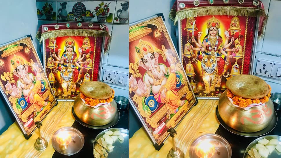
A Roth is a sweet bread kind of a preparation which is first offered to the Goddess and then distributed amongst each other. It is also believed that two local goddesses transformed into one, known as Beeb Garab Maej—the mother goddess who is prayed to on this day.
Also, Lord Ganesha and Goddess Lakshmi are revered in the puja as well. Beeb Garabh Maej, the goddess who is worshipped on this day is seen carrying lota or a water pot which is placed at the Puja area. Then, most importantly, a single long cotton thread is tied to the pot's neck with a handful of dramun or runner grass kept inside it, pointing again to its agricultural origin.
Some of the rice, flowers and dramun grass is then distributed amongst the family members who sit in the puja and the Roth preparations are kept in front of the goddess and earthen pot to signify the prasad offering to the goddess. Also, some fruits are offered to the mother goddess besides Roth.

Legend:

Then a legendary story of the Beeb Garab Maej is read by one person while others attentively pay heed to it. The story is quite similar to the Satyanarayana Katha.

After the story (Katha) has been read, the people present at Pann Puja offer the dramun grass, rice and flowers to the pot and pray with folded hands to the goddess for prosperity and good health.
The prasad of Roth and fruits is consumed by the devotees and the rest of the Roths are distributed amongst friends and family. There is also a tradition which goes like, you distribute the exact number of Roths to particular families respectively and the practice of sharing the Roth prasad should continue year-after-year without a fail.
In the same month, there are different dates when the Roth Prasad can be made and Pann Pooza conducted. But the majority celebrates it on Vinayak Chaturthi.
It signifies prosperity, auspiciousness and holds greater significance in Kashmiri households.
Here's wishing everyone a happy Vinayak Chaturthi and Pann Pooza Mubarak to those celebrating!

Sunday, September 1, 2019

Ganesh Chaturthi

Ganesh Chaturthi

Ganesha Chaturthi (Gaṇēśa Caturthī or Vināyaka Caviti) is the Hindu festival celebrated in honour of the god Ganesha, the elephant-headed. The festival, also known as Vinayaka Chaturthi, is observed in the Hindu calendar month of Bhaadrapada, starting on the shukla chaturthi (fourth day of the waxing moon period). The date usually falls between August and September. The festival usually lasts for 10 days, ending on Anant Chaturdashi (fourteenth day of the waxing moon period).
The modern festival involves installing clay images of Ganesha in public pandals (temporary shrines), which are worshipped for ten days. These are immersed at the end of the festival in a body of water such as a lake, along with the idol. Some Hindus also install the clay images of Ganesha in their homes. The festival was celebrated as a public event since the days of Maratha King Shivaji (1630–1680). However, the public festival as celebrated in Maharashtra today, was introduced by Bhausaheb Laxman Javale in 1892 by installing first Sarvajanik (Public) Ganesh idol- Shrimant Bhausaheb Rangari Ganpati, Bhudwar Peth, in Pune. The first meeting regarding starting the Sarvajanik Ganesh utsav took place under the leadership of Bhausaheb Laxman Javale at his residence (Bhudwar Peth) now known as Bhau Rangari Bhavan. In 1893 Lokmanya Tilak praised the concept of Sarvajanik Ganesh Utsav in Kesari Newspaper. In 1894, he installed Ganesh idol in Kesari wada, Pune too and started preaching Ganesh Utsav.
While celebrated all over India, it is grandest and most elaborate of them especially in Maharashtra, Karnataka, Telangana, Tamilnadu, Kerala, Andhra Pradesh, Goa     and in other parts of Western India and Southern India. Outside India, it is celebrated widely in Terai region of Nepal and by the Hindu diaspora in the United States, Canada, Mauritius, and other places.
Traditional Hindu about Ganesha tell that Parvati, the consort of Shiva, created Ganesha out of sandalwood paste that she used for her bath and breathed life into the figure. She then set him the task of guarding her door while she bathed. Shiva, who had gone out, returned and as Ganesha didn't know him, didn't allow him to enter. After the combat between Ganesha and Shiva Ganas, finally angry Shiva severed the head of the child. Parvati seeing this became enraged and Shiva then promised that her son will be alive again. The devas searched for the head of dead person facing North, but they found only the head of an elephant. They brought the head of the elephant and Shiva fixed it on the child's body and brought him back to life. Lord Shiva also declared that from this day the boy would be called Ganesha (Gana Isha : Lord of Ganas).
According to the Linga Purana, Ganesha was created by Lord Shiva and Goddess Parvati at the request of the Devas for being a Vighnakartaa (obstacle-creator) in the path of Rakshasas, and a Vighnahartaa (obstacle-averter) to help the Devas achieve fruits of their hard work
The festival is observed in the Hindu calendar month of Bhaadrapada, starting on the shukla chaturthi, the fourth lunar day of the waxing moon fortnight.[8] The date usually falls between August and September. The festival lasts for 10 to 12 days, ending on Anant Chaturdashi.
Weeks or even months before Ganesha Chaturthi, artistic clay models of Lord Ganesha are made for sale by skilled artisans. They are beautifully decorated and depict Lord Ganesha in vivid poses. The size of these statues may vary from 3/4 of an inch to over 70 feet.[citation needed]
Ganesha Chaturthi starts with the installation of these Ganesha statues in colorfully decorated homes and specially erected temporary structures mandapas (pandals) in every locality. The pandals are erected by collecting monetary contributions and are decorated specially for the festival, by using decorative items like flower garlands, lights, etc. and at times have theme based decorations.
The priest then with the chanting of mantras invokes the presence of Ganesha using the statue as a channel, or body for his energy. This ritual is the Pranapratishhtha. After this the ritual called as Shhodashopachara (16 ways of paying tribute) follows. Coconut, jaggery, modaks, durva (trefoil) blades of grass and red flowers are offered. The statue is anointed with red unguent, typically made of kumkum and sandalwood paste. Throughout the ceremony, Vedic hymns from the Rig Veda, the Ganapati Atharvashirsa, Upanishad, and the Ganesha stotra from the Narada Purana are chanted.
 Ganesh Chaturthi is an important festival of Maharashtra. It is celebrated by most Hindu households of Maharashtra.[9] In Maharashtra, most Hindu families install their own small clay statues for worship on Ganesh Chaturthi. The idol is worshiped in every morning and evening until the departure. The worship involves various offerings to the idol including flowers and durva. Each durva bunch has 21 shoots and the shoots have either three or five strands. Other offerings like modak also have to number 21 in Ganesh worship,[10][11] The daily worship ceremonies ends with the worshipers singing the Aarti in honor of Ganesh, other Gods and saints. The Ganesh aarti sung in Maharashtra was composed by the 17th century, saint Samarth Ramdas. As per the tradition of their respective families, the domestic celebrations come to an end after 1, 3, 5, 7 or 11 days when the statue is taken in a procession to a large body of water such as a lake, river or the sea for immersion. Due to environmental concerns, a number of families now avoid the large water bodies and instead let the clay statue disintegrate in a bucket or tub of water at home. After a few days the clay is used in the home garden. In some cities, a public eco-friendly process is used for immersion.

Public celebrations of the festival are hugely popular especially in Maharashtra. These are organised by local youth groups (Tarun Mandal), neighborhood associations or group of traders. An example of the latter is the celebrations organized by the vegetable market traders in Pune. The Mandai Ganpati as it is called has been installed every year since the 1890s. The funds for the public festival are collected from members of the association arranging the celebration, local residents or local businesses The Ganesh and accompanying statues are installed in temporary shelter called mandap or pandals. The local Festival Committees vie with each other to put up the biggest statue and the best pandal. The festival is also the time for cultural activities like singing and theater performances, orchestra and community activities like free medical checkup, blood donation camps, and charity for the poor.
Today, the Ganesh Festival is not only a popular festival, it has become a very critical and important economic activity for Mumbai, Pune, Hyderabad, Bangalore and Chennai. Many artists, industries, and businesses earn a significant amount of their living from this Festival. Ganesh Festival also provides a stage for budding artists to present their art to the public. In Maharashtra, not only Hindus but many other religions also participate in the celebration like Muslims, Jains, Christian and others.

The most serious impact of the festival on the environment is due to the immersion of idols made of Plaster of Paris into lakes, rivers and the sea. Traditionally, the idol was sculpted out of mud taken from nearby one’s home. After the festival, it was returned to the Earth by immersing it in a nearby water body. This cycle was meant to represent the cycle of creation and dissolution in Nature.
However, as the production of Ganesh idols on a commercial basis grew, the earthen or natural clay (shaadu maati in Marathi and banka matti in Telugu) was replaced by Plaster of Paris. Plaster is a man-made material, easier to mould, lighter and less expensive than clay. However, plaster is non-biodegradable, and insoluble in water. Moreover, the chemical paints used to adorn these plaster idols themselves contain heavy metals like mercury and cadmium, causing water pollution. Also, on immersion, non-biodegradable accessories that originally adorned the idol accumulate in the layers of sand on the beach.
In the Republic of Trinidad and Tobago, Radio Jaagriti, the leading Hindu radio station in the country, has actively educated the public of the environmental implications of the use of plaster of Paris murtis. Clay Lord Ganeshas have been encouraged to be used for immersion into the water courses to prevent any harmful environmental impacts. Ganesh Chaturthi is a widely celebrated Hindu Festival in Trinidad and Tobago.
In Goa, the sale of Ganesh idols made from Plaster of Paris (PoP) is banned by the State Government. People are urged to buy traditional clay idols made by artisans.[33]
Recently there have been new initiatives sponsored by some state governments to produce clay Ganesha idols.[34]
Artificial pool created to immerse Plaster of Paris idols.
On the final day of the Ganesh festival thousands of plaster idols are immersed into water bodies by devotees. These increase the level of acidity in the water and the content of heavy metals.[35] Several non-governmental and governmental bodies have been addressing this issue. Amongst the solutions proposed are as follows:
  • Return to the traditional use of natural clay idols and immerse the icon in a bucket of water at home.
  • Use of a permanent icon made of stone and brass, used every year and a symbolic immersion only.
  • Recycling of plaster idols to repaint them and use them again the following year.
  • Ban on the immersion of plaster idols into lakes, rivers and the sea.[36]
  • Creative use of other biodegradable materials such as papier-mâché to create Ganesha idols.
  • Encouraging people to immerse the idols in tanks of water rather than in natural water bodies.
To handle religious sentiments sensitively, some temples and spiritual groups have taken up the caus

  CELEBRATION BY KASHMIRI PANDITS
Pan Dyun: 'Ryetav manza ryethah, Baedearpyethah, Venayka Tsoram to Aathvar'- The month is Bhadrapada, the day fourth day of the bright fortnight and hopefully a Sunday. This is the festival known all over the country as Ganesh Chaturthi and celebrated in Kashmir in a unique way. Early morning a metal pot is cleaned and placed at a suitable clean place, with some water filled in it. The ladies of the house prepare a sweet pancake called 'Roth'. Poppy seeds are fixed over these on both the sides. The family members sit near the pot and the lady of the house narrates a story of Beeb garaz Maej (click here). This story has a moral that by performing pooja of Shri Ganesha on this day, preparing sweet pancake and offering the same to the deity, poverty and the miseries of the person are removed and one lives a pious life full of comfort. The story is very similar to the one narrated on the occasion of the Satya Narayana Pooja. After listening to the story, all the members fill the pot with flowers and a specific variety of green grass, which they hold in their hands throughout the narration of the story. The sweet pancake prepared on this day becomes the prashada and is distributed among relatives, friends and neighbours. Distribution of such things as Tahaer, Roth, Yogurt, cakes, walnuts is a common feature of the Kashmiri life and helps make it a close-knit community bound by love, concern and care for each other.
PAN DUEN is another important festival of Kashmiri Pandits celebrated since time immemorial. The festival though different of its kind enjoys tremendous reverence and popularity in all KP families wherever they’re. It’s celebrated by making a special bread cake called ROTH in Kashmiri. The wheat floor in sufficient quantity is mixed with ghee, sugar, cardamom and poppy seeds and made into dough before thick Roties are rolled and deep-fried in ghee on low heat. The quantity of the material depends mainly on the tradition of the house and the strength of the family and its extension as the Prasad has to be shared with all relatives and friends after the Pooja concludes. The auspiciousness of the occasion demands enough preparation from vigorous cleaning of the whole house especially the kitchen place to a get together of all the members of family to give the process enough sanctity. The head lady of the house takes full charge of the occasion with the juniors working under her and the work is started early in the morning after doing all washing and collecting fresh water as everything has to be done with extreme purity of hand and heart as well. The recitations of holy mantras continue throughout the process as no gossips are allowed considering the sanctity of the occasion.
The Mahurat (auspicious occasion) for PAN DEUN are a few dates in the bright lunar fortnight of Bhadroon around Ganesh Chuturthi festival celebrated throughout India with full gaiety and devotion. In Kashmir the festival is celebrated by the name Vinayak Chorum and the most favoured Mahurat for PAN DEUN especially if it’s a Sunday lovingly called Vinayak Choram Te Aathwaar. This year interestingly Ganesh Chaturthi was on Sunday but Chorum (4th day of the lunor fortnight) was missing in the calendar. It was the 3rd lunar day so not favoured for PAN DEUN.
Now after the recipe (PAN ROTH) is ready there is a ceremonial ritual considered very auspicious. All the prepared PAN ROTH are kept in a large wicker basket and covered with a freshly washed clean cotton cloth. A big Lota (Gadvei) of brass, now stainless-steel is filled with fresh water and after decorating it with a flower garland, Naervan (moli), sindoor, etc it is covered with a big size ROTH and a couple or more small ones and some dry fruit, shelled walnuts and some sugar candy for Prasad and kept ceremoniously on the floor while all the family members surround it with folded hands facing East. The head lady ties Naerwan and puts Tikka on the forehead of all the members and takes in her hand the cotton thread which she had been keeping on her right ear during the making of PAN ROTH. The cotton thread is mainly significant in this ritual. In olden days the cotton thread was especially twisted for the purpose out of fresh cotton wool grown in Kashmir by an unmarried young girl on the family Charkha as Goddess Durga was worshipped in her maiden form on the occasion. The thread is called PAN in Kashmiri.
All the members take in their folded hands some washed grains of rice, barley and flowers along with a little of fresh washed running grass with roots (Dramun) which grows wildly everywhere on roadsides and parks and the head lady with all sanctity relates a traditional story of a woman of yester-years called Bib Dhara Maej who used to observe the ritual with all sanctity and was very prosperous enjoying all the blessings of the Lord. Unfortunately one such day while preparing PAN ROTH with all sanctity along with her unmarried young daughter, her husband, a rich man and too conceited came in the house unexpectedly and the fit of some anger spoiled the sanctity of the ritual and left the house. Within no time the worst misfortune overcame him and the whole family. He was deprived of all his riches, name and fame till the situation reached that the family were reduced to penury. The lady couldn’t forget the episode and in most deprived conditions arranged for the ritual the next year and surprisingly their misfortune was replaced by former riches and glory once again. As the story is ceremoniously related in full the head lady opens the lid of the Lota and offers the rice and barley grains with flowes in her hand to the Lord followed by all other mambers of the family. Thus is ritual ends with everyone wishing for good heath and prosperity and the Prasad is taken.
Now the PAN NAVEED as it’s called is to be shared with all relatives and friends and the main share is given to the married daughters and sisters in the family along with the Tikka and Naerwan from the Pooja within next few days. After the displacement of Pandits from Kashmir the new found non-Kashmiri relatives, friends and neighbours eagerly wait for the PAN NAVEED for its sanctity and high taste. 


 POSTED BY ...VIPUL KOUL
EDITED BY......ASHOK KOUL