
Exploring the Remote Mountains of the Eastern Himalayas
Arunachal Pradesh, India
Amar Dev Singh
My computer screen was cluttered with
layers of open windows of spreadsheets, charts, calendars, emails and
the usual other office stuff but the window that really had my interest
was hidden just below. It was a window into the unknown.
In-between cups of coffee and meetings I was exploring Google Maps
peering into the depths of the remotest and least explored corners of
the Himalayas – the Eastern Himalayas of India. I was looking for a
line, a route, a challenge. I traced the folds of the terrain and
followed the forbidden borders near a place called The Tri Junction,
where the borders of Tibet, Burma and India intersect.
Months of searching revealed an elegant line that connects two river systems, the Ghalum and the Sar Di rivers, both tributaries of the Lohit River that originates deep in the Tibetan plateau. A 4500m pass right near the Burmese border separates the watersheds of these two rivers. The pass had neither a name nor was there any record that it had been crossed. I had found what I was looking for!
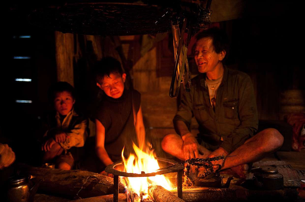
Six months later I was driving in the pouring rain along a twisted Himalayan road that runs along the Lohit river. I was on a recce to find out if the route was possible to follow. After a bone shaking 15-hour drive from the nearest airport we reached the trail head. Minzong consisted of a handful of rough bamboo huts elevated on stilts. Chickens, cattle and pigs wandered around in the mud and drizzle. We hopped over muddy puddles and animal dung as we made our way to the nearest hut. A local from the Mishimi tribe opened his door and beckoned us to come in out of the rain. Warm hospitality is second nature to these people. We sat cross-legged by the fire as they prepared tea for us.
The Mishimi people live very traditional lives and the Spartan hut had almost nothing in it; a few clothes hanging from pegs and a couple of farming implements lying in the corner. The only decoration was a hunter’s trophy rack consisting of a collection of skulls: bear, monkey, buffalo and deer.
Over a few cups of tea we asked if anyone knew of a route up the Ghalum river into the interior. They affirmed that local hunters do make the occasional foray up the valley and there is an old trade route that leads into Burma over the Kumjawng Pass. They noted that not many, if any people, had ventured beyond the pass in the direction I wanted to explore.
Months of searching revealed an elegant line that connects two river systems, the Ghalum and the Sar Di rivers, both tributaries of the Lohit River that originates deep in the Tibetan plateau. A 4500m pass right near the Burmese border separates the watersheds of these two rivers. The pass had neither a name nor was there any record that it had been crossed. I had found what I was looking for!
Six months later I was driving in the pouring rain along a twisted Himalayan road that runs along the Lohit river. I was on a recce to find out if the route was possible to follow. After a bone shaking 15-hour drive from the nearest airport we reached the trail head. Minzong consisted of a handful of rough bamboo huts elevated on stilts. Chickens, cattle and pigs wandered around in the mud and drizzle. We hopped over muddy puddles and animal dung as we made our way to the nearest hut. A local from the Mishimi tribe opened his door and beckoned us to come in out of the rain. Warm hospitality is second nature to these people. We sat cross-legged by the fire as they prepared tea for us.
The Mishimi people live very traditional lives and the Spartan hut had almost nothing in it; a few clothes hanging from pegs and a couple of farming implements lying in the corner. The only decoration was a hunter’s trophy rack consisting of a collection of skulls: bear, monkey, buffalo and deer.
Over a few cups of tea we asked if anyone knew of a route up the Ghalum river into the interior. They affirmed that local hunters do make the occasional foray up the valley and there is an old trade route that leads into Burma over the Kumjawng Pass. They noted that not many, if any people, had ventured beyond the pass in the direction I wanted to explore.
Chickens, cattle and pigs wandered around in the mud and drizzle. We hopped over muddy puddles and animal dung as we made our way to the nearest hut. A local from the Mishimi tribe opened his door and beckoned us to come in out of the rain.
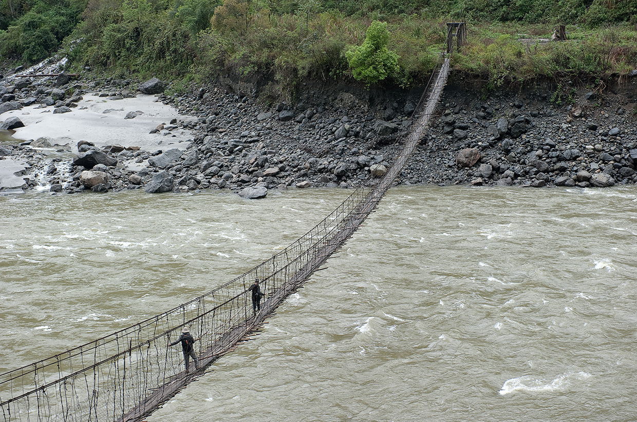
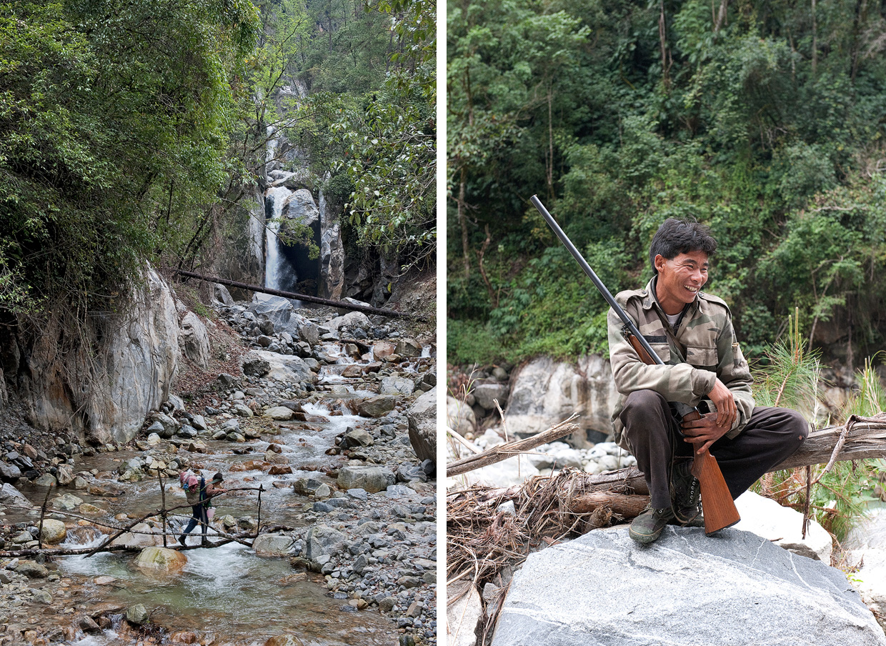
Early next day we started up the Ghalum valley
to scout the initial section of the route. It began with an exciting
crossing of a very sketchy suspension bridge over the swirling waters of
the Lohit. The rusty cables were held together with even rustier
off-cuts of wire and rough planks were slippery and loose. On the far
side a well-worn path snaked its way through the jungle, hugging the
course of the roaring Ghalum river, till the last village of Baon.
Beyond that lay the jungle.
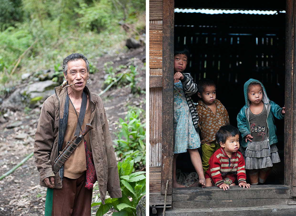
Along the way we passed a number of huts surrounded by poppy fields.
Most of the locals are hopelessly addicted to opium. A few women and
grubby kids stared at us in silence before withdrawing into the dark
recesses of the huts. Newly erected electricity poles and wires were the
only sign of modernity in this quiet valley. Baon had only recently
been hooked up to the electricity grid; that’s over 200 years after the
invention of the light bulb.
Smoke filtered through the thatched ceiling, indicating that someone was home. We called out and a friendly face popped out of the door. The man quickly recovered from his initial surprise and invited us in.
We crossed and recrossed the Ghalum river a
number of times on suspension bridges in various states of disrepair.
Animist shrines and totems marked the path along the way. The local
people follow the animist Doni Polo religion and worship the sun and the
moon.
After a few hours of trekking we came across the first huts of the
village, rough bamboo structures balanced on stilts. Chickens and pigs
scratched around in the ubiquitous poppy fields around the huts. Smoke
filtered through the thatched ceiling, indicating that someone was home.
We called out and a friendly face popped out of the door. The man
quickly recovered from his initial surprise and invited us in. We kicked
off our shoes and stumbled into the gloomy smoke-filled interior. We
were seated by the fire on bear skins and over sweet cups of tea we
quizzed the locals about the route beyond the village.
All the people in these parts speak Hindi fluently. The Indian government has gone to great length to ‘Indianise’ the people of Arunachal to counter China’s claim of the state. China refers to Arunachal Pradesh as Zàngnán or ‘South Tibet’ and regard it as Indian-occupied Chinese territory. The borders of this frontier state have never been officially demarcated. In 1962 India and China went to war and the Lohit valley was the scene of some bloody battles. The area remains heavily militarised and special permits are required to travel here.
We were assured that there was indeed a route for the next four days till the Kamjung Pass that leads into the jungles of Burma. The Indian military runs a couple of patrols up till the pass every year.

We made our way back down the valley to
the roadhead, satisfied with the knowledge that this section of the
route could be done. Now to find out about the route up the Sar Di river
which would be the descent route for the expedition. It took us two
days to cover the 40km to the village of Dong as the early rains had
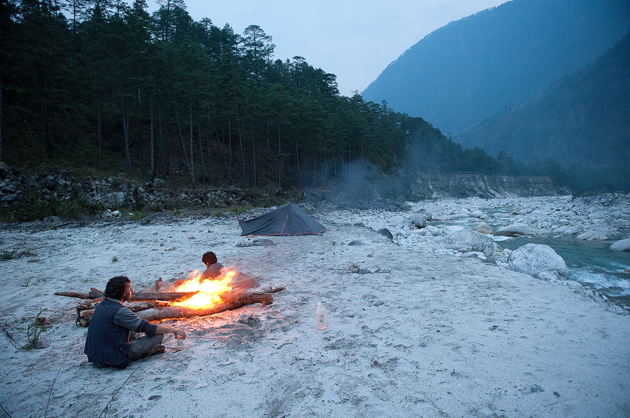
washed away the road. We camped by some hot springs on the banks of the
Lohit and put the word out on the bush telegraph that we were looking to
hire the services of a local guide and porters.
Just before dark three guys from the Meyor tribe showed up. Their
leader Ajo, a quietly confident man, was an experienced hunter and knew
the valley very well. He had bought two of his nephews along. They were
just teenagers but Ajo assured us that they were very capable. We
needn’t have worried as they turned out to be seasoned bushmen and could
put the best of us to shame.
We paired our belongings down to a few bare essentials necessary for a two-day recce. The locals stood around as we repacked and shook their heads in disbelief at the amount of useless paraphernalia that we were carting along. All they packed for the trip was a blanket, a bush knife, matches, a cooking pot and a small bundle of food. These guys were hard as nails.
We set out before dawn and crossed the sparkling clear waters on a small suspension bridge at first light. The jungle began on the far side of the river and that’s where the path abruptly ended. We were now on a game trail that snaked it’s way up along the Sar Di river.
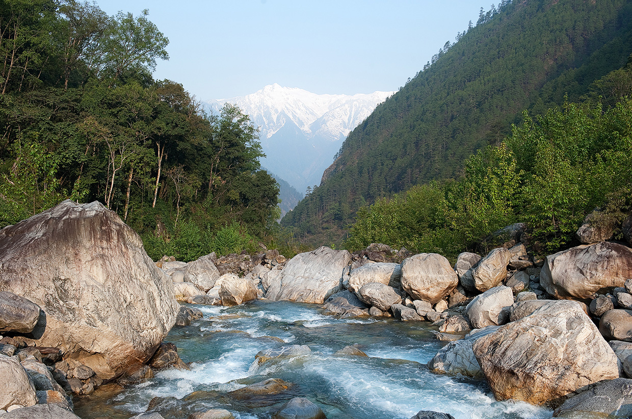
The trail climbed up and down along the precariously steep sides of the valley, which echoed with the roar of the rapids. Thick sub tropical jungle, thickets of bamboo, tangles of vines and dense undergrowth covered the hillsides. These jungles are teeming with wildlife; leopards, bears, monkeys and deer; Snow Leopard and Yak inhabit the higher reaches above the tree line.
We had to keep within a few feet of each other otherwise we would loose our way in the dense undergrowth of the jungle. Ajo and his merry gang laughed and whistled their way while we stumbled behind them. We had to cross the river on a number of occasions and the bridges didn’t inspire any confidence. They consisted of a single bamboo pole to walk on with a flimsy handrail lashed together with vines. There would be little hope if you fell into the frigid waters with a loaded rucksack strapped onto your back.
As I was crossing one of these heinous constructions I noticed a fresh leopard turd balanced on the log. I smiled and took solace from the fact that the king of this jungle had to empty his bowels before making the precarious crossing.
We trekked for hours though the jungle, traversing steep slopes and crossing and recrossing the river. Ajo wove his way between boulders, up and down gullies, and across steep rocky terrain like he was strolling in his backyard. There was no real path anymore; he was just picking the line of least resistance. I am glad we had him with us, without him we would have been floundering around in the jungle.
It was starting to get late and we had been going all day. We had covered only around 16 km of challenging terrain. The valley was very steep and there weren’t many suitable campsites. Ajo guided us to a clearing by the river. This was as far as we planned to go on this recce. It had given us a good idea of the kind of terrain we would encounter when we would return to venture deeper into the valley.
We paired our belongings down to a few bare essentials necessary for a two-day recce. The locals stood around as we repacked and shook their heads in disbelief at the amount of useless paraphernalia that we were carting along. All they packed for the trip was a blanket, a bush knife, matches, a cooking pot and a small bundle of food. These guys were hard as nails.
We set out before dawn and crossed the sparkling clear waters on a small suspension bridge at first light. The jungle began on the far side of the river and that’s where the path abruptly ended. We were now on a game trail that snaked it’s way up along the Sar Di river.
The trail climbed up and down along the precariously steep sides of the valley, which echoed with the roar of the rapids. Thick sub tropical jungle, thickets of bamboo, tangles of vines and dense undergrowth covered the hillsides. These jungles are teeming with wildlife; leopards, bears, monkeys and deer; Snow Leopard and Yak inhabit the higher reaches above the tree line.
We had to keep within a few feet of each other otherwise we would loose our way in the dense undergrowth of the jungle. Ajo and his merry gang laughed and whistled their way while we stumbled behind them. We had to cross the river on a number of occasions and the bridges didn’t inspire any confidence. They consisted of a single bamboo pole to walk on with a flimsy handrail lashed together with vines. There would be little hope if you fell into the frigid waters with a loaded rucksack strapped onto your back.
As I was crossing one of these heinous constructions I noticed a fresh leopard turd balanced on the log. I smiled and took solace from the fact that the king of this jungle had to empty his bowels before making the precarious crossing.
We trekked for hours though the jungle, traversing steep slopes and crossing and recrossing the river. Ajo wove his way between boulders, up and down gullies, and across steep rocky terrain like he was strolling in his backyard. There was no real path anymore; he was just picking the line of least resistance. I am glad we had him with us, without him we would have been floundering around in the jungle.
It was starting to get late and we had been going all day. We had covered only around 16 km of challenging terrain. The valley was very steep and there weren’t many suitable campsites. Ajo guided us to a clearing by the river. This was as far as we planned to go on this recce. It had given us a good idea of the kind of terrain we would encounter when we would return to venture deeper into the valley.
The locals stood around as we repacked and shook their heads in disbelief at the amount of useless paraphernalia that we were carting along. All they packed for the trip was a blanket, a bush knife, matches, a cooking pot and a small bundle of food. These guys were hard as nails.
Ajo unsheathed his bushknife and got to
work clearing the shrubs and undergrowth while his companions dropped
their loads and disappeared into the forest to collect wood for the
fire. They had been carrying heavy loads but didn’t show any sign of
fatigue. We pitched our tents and laid out our sleeping bags while the
others made a bivi in a cave under a large boulder. The fire was lit and
we began preparing an evening meal of rice and vegetables.
Once comfortable, we climbed a large boulder that gave us a good view
up and down the valley. The sun was setting and the jungle was turning
dark. Unnamed snow-clad mountains on the Burmese border glowed
tantalisingly in the fading light. I smiled to myself as I sipped a hot
cup of sweet tea for I knew the adventure had only just begun. I would
be back next year to venture deeper into the depths of these remote
valleys.
Amar Dev Singh is an expedition leader, project manager, photographer and writer based in Melbourne, Australia. He has over 20 years of experience organising expeditions and trips to remote and interesting parts of the world where he snaps stunning photographs that many of us only dream of. You can find him on his website, Facebook and Twitter.
Amar Dev Singh is an expedition leader, project manager, photographer and writer based in Melbourne, Australia. He has over 20 years of experience organising expeditions and trips to remote and interesting parts of the world where he snaps stunning photographs that many of us only dream of. You can find him on his website, Facebook and Twitter.


No comments:
Post a Comment