| Shimla Simla |
|
|---|---|
| City | |

Clockwise from top: Skyline at Shimla Southern Side, Indian Institute of Advanced Studies, Town Hall, Night view of Shimla and Christ Church.
|
|
| Nickname(s): Queen of Hills/ पहाड़ों की रानी | |
| Coordinates: 31°6′12″N 77°10′20″ECoordinates: 31°6′12″N 77°10′20″E | |
| Country | |
| State | Himachal Pradesh |
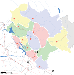
| District | Shimla |
| Named for | Hindu goddess Shyamala Devi[1] |
| Government | |
| • Type | Municipal Corporation |
| • Body | Shimla Municipal Corporation |
| • Municipal Commissioner | Deepsikha Bhardwaj IAS |
| • Mayor | Vacant |
| Area[2] | |
| • City | 35.34 km2 (13.64 sq mi) |
| Elevation | 2,276 m (7,467 ft) |
| Population (2011)[3][4] | |
| • City | 269,578 |
| • Rank | 1 (in HP) |
| • Density | 7,600/km2 (20,000/sq mi) |
| • Metro[3] | 291,640 |
| Languages | |
| • Official | Hindi, English |
| Time zone | IST (UTC+5:30) |
| PIN | 171 001 |
| Telephone code | 91 177 XXX XXXX |
| ISO 3166 code | ISO 3166-2 |
| Vehicle registration |
HP HP-03 , HP-51, |
| Climate | Cwb |
| Precipitation | 1,577 mm (62 in) |
| Avg. annual temperature | 17 °C (63 °F) |
| Avg. summer temperature | 22 °C (72 °F) |
| Avg. winter temperature | 7 °C (45 °F) |
| Website | hpshimla |
Small hamlets were recorded prior to 1815 when British forces took control of the area. The climatic conditions attracted the British to establish the city in the dense forests of Himalayas. As the summer capital, Shimla hosted many important political meetings including the Simla Accord of 1914 and the Simla Conference of 1945. After independence, the state of Himachal Pradesh came into being in 1948 as a result of integration of 28 princely states. Even after independence, the city remained an important political centre, hosting the Simla Agreement of 1972. After reorganisation of state of Himachal Pradesh, the existing Mahasu district was named Shimla. Its name is derived from the goddess Shyamala Devi, an incarnation of the Hindu goddess Kali.[citation needed]
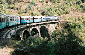
Shimla is home to a number of buildings that are styled in the Tudorbethan and neo-Gothic architectures dating from the colonial era, as well as multiple temples and churches. The colonial architecture and churches, the temples and the natural environment of the city attracts tourists. Attractions include the Viceroy Lodge, the Christ Church, the Jakhoo Temple, the Mall Road and the Ridge, which together form the city centre. The Kalka–Shimla Railway line built by the British, a UNESCO World Heritage Site, is also a major tourist attraction. Owing to its steep terrain, Shimla hosts the mountain biking race MTB Himalaya, which started in 2005 and is regarded as the biggest event of its kind in South Asia. Shimla also has the largest natural ice skating rink in South Asia. Apart from being a tourism centre, the city is also an educational hub with a number of colleges and research institutions.
History
The vast majority of the area occupied by the present-day Shimla city was dense forest during the 18th century. The only civilisation consisted of the Jakhoo temple and a few scattered houses.[5] The area was called 'Shimla', named after a Hindu goddess, Shyamala Devi, an incarnation of Kali.[1]
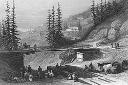
The bridge connecting Shimla with Chhota Shimla, originally erected in 1829 by Lord Combermere, Shimla, 1850s
In 1832, Shimla saw its first political meeting: between the Governor-General William Bentinck and the emissaries of Maharaja Ranjit Singh. In a letter to Colonel Churchill, he wrote:[7]
| “ | Shimla is only four days march from Loodianah (Ludhiana), is easy of access, and proves a very agreeable refuge from the burning plains of Hindoostaun (Hindustan). | ” |
In 1863, the Viceroy of India, John Lawrence, decided to shift the summer capital of the British Raj to Shimla.[5] He took the trouble of moving the administration twice a year between Calcutta and this separate centre over 1,000 miles away, despite the fact that it was difficult to reach.[9] Lord Lytton (Viceroy of India 1876–1880) made efforts to plan the town from 1876, when he first stayed in a rented house, but began plans for a Viceregal Lodge, later built on Observatory Hill. A fire cleared much of the area where the native Indian population lived (the "Upper Bazaar" nowadays known as the Ridge[10]), and the planning of the eastern end to become the centre of the European town forced them to live in the Middle and Lower Bazaars on the lower terraces descending the steep slopes from the Ridge. The Upper Bazaar was cleared for a town hall, with many facilities such as library and theatre, as well as offices for police and military volunteers as well as municipal administration.
During the "Hot Weather", Shimla was also the Headquarters of the Commander-in-Chief, India, the head of the Indian Army, and many Departments of the Government. The summer capital of the regional Government of the Punjab moved from Murree, in modern-day Pakistan, to Shimla in 1876. They were joined by many of the British wives and daughters of the men who remained on the plains. Together these formed Shimla Society, which, according to Charles Allen,[11] "was as close as British India ever came to having an upper crust." This may have been helped by the fact that it was very expensive, having an ideal climate and thus being desirable, as well as having limited accommodation. British soldiers, merchants and civil servants moved here each year to escape from the heat during summer in the Indo-Gangetic plain. The presence of many bachelors and unattached men, as well as the many women passing the hot weather there, gave Shimla a reputation for adultery, and at least gossip about adultery: as Rudyard Kipling said in a letter cited by Allen, it had a reputation for "frivolity, gossip and intrigue". (See also.[12])
The 500-foot (150 m) Lower Bazaar tunnel was built in 1905 and christened Khachhar Surang. The Elysium tunnel (now known as the Auckland Tunnel), about 120 feet (37 m) in length, was also built in 1905.[8]
Passenger train on the Kalka-Shimla Railway route
Entrance of the Crowborough Rest House built in 1921
Pre-independence structures still dot Shimla; buildings such as the former Viceregal Lodge, Auckland House, Christ Church, Gorton Castle, Shimla Town Hall and the Gaiety Theatre are reminders of British rule in India.[15][16] The original Peterhoff, another Viceregal residence, burned down in 1981. British Shimla extended about a mile and a half along the ridge between Jakhoo Hill and Prospect Hill. The central spine was the Mall, which ran along the length of the ridge, with a Mall Extension southwards, closed to all carriages except those of the Viceroy and his wife.
Geography
Shimla lies in the south-western ranges of the Himalayas at 31.61°N 77.10°E. It has an average altitude of 2,206 metres (7,238 ft) above mean sea level and extends along a ridge with seven spurs. The city stretches nearly 9.2 kilometres (5.7 mi) from east to west.[17] Shimla was built on top of a total of seven different hills namely: Inverarm Hill, Observatory Hill, Prospect Hill, Summer Hill, Bantony Hill, Elysium Hill and Jakhoo Hill. The highest point in Shimla is the Jakhoo hill, which is at a height of 2,454 metres (8,051 ft).The city is a Zone IV (High Damage Risk Zone) per the Earthquake hazard zoning of India. Weak construction techniques and an increasing population pose a serious threat to the already earthquake prone region.[18][19] There are no water bodies near the main city and the closest river, the Sutlej, is about 21 km (13 mi) away.[20] Other rivers that flow through the Shimla district, although further from the city, are the Giri, and Pabbar (both tributaries of Yamuna).
The green belt in the Shimla planning area is spread over 414 hectares (1,020 acres).[12] The main forests in and around the city are of pine, deodar, oak and rhododendron.[21] Environmental degradation due to the increasing number of tourists every year without the infrastructure to support them has resulted in Shimla losing its popular appeal as an ecotourism spot.[22] Another rising concern in the region are the frequent number of landslides that often take place after heavy rains.[18][23]
The city is situated 88 km (55 miles) northeast of Kalka, 116 km (72 miles) northeast of Chandigarh, 247 km (154 miles) south of Manali and 350 km (219 miles) northeast of Delhi, the national capital. Kalka can be reached within 2.5 hours, Chandigarh can be reached in 3 hours and 15 minutes. Delhi and Manali are both around 7 hours away from Shimla.
Climate
Foggy rain in Shimla (June)
The average temperature during summer is between 19 and 28 °C (66 and 82 °F), and between −1 and 10 °C (30 and 50 °F) in winter. Monthly precipitation varies between 15 millimetres (0.59 in) in November and 434 millimetres (17.1 in) in August. It is typically around 45 millimetres (1.8 in) per month during winter and spring, and around 175 millimetres (6.9 in) in June as the monsoon approaches.
The average total annual precipitation is 1,575 millimetres (62 in), which is much less than most other hill stations but still much heavier than on the plains. Snowfall in the region, which historically has taken place in the month of December, has lately (over the last fifteen years) been happening in January or early February every year.[26]
The maximum snowfall received in recent times was 38.6 centimetres (15.2 in) on 18 January 2013. On two consecutive days (17 and 18 January 2013), the town received 63.6 centimetres (25.0 in) of snow.[27]
| [hide]Climate data for Shimla (1971–2000) | |||||||||||||
|---|---|---|---|---|---|---|---|---|---|---|---|---|---|
| Month | Jan | Feb | Mar | Apr | May | Jun | Jul | Aug | Sep | Oct | Nov | Dec | Year |
| Record high °C (°F) | 21.4 (70.5) |
22.6 (72.7) |
25.8 (78.4) |
29.6 (85.3) |
32.4 (90.3) |
31.5 (88.7) |
28.9 (84) |
27.8 (82) |
28.6 (83.5) |
25.6 (78.1) |
23.5 (74.3) |
20.5 (68.9) |
32.4 (90.3) |
| Average high °C (°F) | 9.3 (48.7) |
10.3 (50.5) |
14.5 (58.1) |
19.8 (67.6) |
23.0 (73.4) |
23.8 (74.8) |
21.3 (70.3) |
20.5 (68.9) |
20.4 (68.7) |
18.9 (66) |
15.4 (59.7) |
11.9 (53.4) |
17.5 (63.5) |
| Average low °C (°F) | −1.2 (29.8) |
2.4 (36.3) |
6.1 (43) |
10.8 (51.4) |
13.6 (56.5) |
15.1 (59.2) |
14.6 (58.3) |
14.2 (57.6) |
12.9 (55.2) |
10.5 (50.9) |
7.0 (44.6) |
4.0 (39.2) |
9.5 (49.1) |
| Record low °C (°F) | −10.6 (12.9) |
−8.5 (16.7) |
−6.1 (21) |
−1.3 (29.7) |
1.4 (34.5) |
7.8 (46) |
9.4 (48.9) |
10.6 (51.1) |
5.0 (41) |
0.2 (32.4) |
−1.1 (30) |
−12.2 (10) |
−12.2 (10) |
| Average precipitation mm (inches) | 53.0 (2.087) |
63.8 (2.512) |
68.9 (2.713) |
61.3 (2.413) |
83.8 (3.299) |
185.3 (7.295) |
333.0 (13.11) |
296.7 (11.681) |
148.7 (5.854) |
36.3 (1.429) |
22.5 (0.886) |
21.4 (0.843) |
1,374.6 (54.118) |
| Average snowfall cm (inches) | 42 (16.5) |
43 (16.9) |
7 (2.8) |
0 (0) |
0 (0) |
0 (0) |
0 (0) |
0 (0) |
0 (0) |
0 (0) |
0 (0) |
7 (2.8) |
99 (39) |
| Average rainy days | 4.5 | 5.3 | 5.9 | 4.6 | 6.3 | 10.1 | 17.2 | 16.2 | 8.8 | 2.2 | 1.5 | 1.8 | 84.5 |
| Average snowy days | 4.2 | 4.2 | 1.4 | 0.0 | 0.0 | 0.0 | 0.0 | 0.0 | 0.0 | 0.0 | 0.1 | 1.3 | 11.2 |
| Source: India Meteorological Department (record high and low up to 2010, snow, 1990–2010)[28][29][30] | |||||||||||||
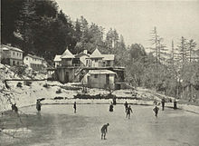
Skating at Simla, c. 1905
Rashtrapati Niwas, Shimla, former "Viceregal Lodge", built 1888
Simla and Jutogh, 1911 map
Economy
Employment is largely driven by the government and tourism sectors.[31] Education sector and horticultural produce processing comprise most of the remainder. Recently a Model Career Centre hasIn addition to being the local hub of transport and trade, Shimla is the area's healthcare centre, hosting a medical college and four major hospitals:[32] Indira Gandhi Hospital (Snowdown Hospital,) Deen Dayal Upadhyay Hospital (formerly called Ripon Hospital), Kamla Nehru Hospital and Indus Hospital. The city's development plan aims make Shimla an attractive health tourism spot.[31]
The hotel industry is one of the major source of income generation for the city. Shimla leads the list of Indian cities with the highest ranked hotels.[33]
National Academy of Audits and Accounts, Yarrows
Government is trying to promote technology and IT sector as the new area for growth and promotion[35] although not many companies have yet settled in Shimla. There are many new startups in and around Shimla. There are over six call centres in Shimla, including Alturist Technologies and 31 Parallel. Two notable companies that are registered in Shimla are Netgen IT Solutions, an international website development startup with partner offices in USA and Australia, and Himachal Media, a company that deals with content and media publishing.
Civic administration
Town Hall as seen from The Ridge
The administrative head of the corporation is the commissioner who is appointed by the state government.
The two major political parties are the Bharatiya Janata Party and Indian National Congress with a third party, Communist Party of India (Marxist), emerging.[37]
The city contributes one seat to the state assembly (Vidhan Sabha) and one seat to the lower house of parliament (Lok Sabha).[38] Law and order in the city is collectively maintained by the police force, Vigilance Department, enforcement directorate, forensics, fire brigade, prisons service and Home Guard. There are five police stations and three fire stations in Shimla.[39] The Superintendent of Police, Shimla heads the police force. The First Armed Police Battalion, one of the four armed police battalions in the state, is available for assistance to the local police.[40]
There are eleven courts in the district including a fast-track court.[41]
Demographics
According to 2011 census, Shimla city spread over an area of 35.34 km2 had a population of 169,578 with 93,152 males and 76,426 females.[2][3] Shimla urban agglomeration had a population of 171,817 as per provisional data of 2011 census, out of which males were 94,797 and females were 77,020.[42] The literacy rate of city was 93.63 percent[3] and that of urban agglomeration was 94.14 per cent.[42]The city area has increased considerably along with passage of time. It has stretched from Hiranagar to Dhalli from one side & from Tara Devi to Malyana in the other. As per the 2001 India Census,[43] the city has a population of 142,161 spread over an area of 19.55 km².[17] A floating population of 75,000 is attributed to service industries such as tourism.[17] The largest demographic, 55%, is 16–45 years of age. A further 28% of the population are younger than 15 years. The low sex ratio – 930 girls for every 1,000 boys in 2001[44] – is cause for concern, and much lower than the 974 versus 1,000 for Himachal Pradesh state as a whole.
The unemployment rate in the city has come down from 36% in 1992 to 22.6% in 2006. This drop is attributed to recent industrialisation, the growth of service industries, and knowledge development.[45] 84% of the population of Shimla city is literate, compared to 80% in Shimla district and 83.87% in the entire state.[46] The majority of Shimla's population consists of natives of Himachal Pradesh.
Hindi is the lingua franca of the city, it is the principal spoken language of the city and also the most commonly used language for the official purposes. English is also spoken by a sizeable population, and is the second official language of the city. Other than Hindi, Pahari languages is spoken by the ethnic Pahari people, who form a major part of the population in the city. Punjabi language is prevalent among the ethnic Punjabi migrant population of the city, most of whom are refugees from West Punjab, who settled in the city after the Partition of India in 1947. According to 2011 census, the majority religion of city is Hinduism practised by 93.5% of the population, followed by Islam (2.29%), Sikhism (1.95%), Buddhism (1.33%) and Christianity (0.62%).[3]
Culture
Stained glass windows at Christ Church (1850), Shimla
Shimla has a number of places to visit. Local hangouts like the Mall and the Ridge are in the heart of the city. Most of the heritage buildings in the city are preserved in their original 'Tudorbethan' architecture. The former Viceregal Lodge, which now houses the Indian Institute of Advanced Study, and Wildflower Hall, now a luxury hotel, are some of the famous ones. A collection of paintings, jewellery and textiles of the region can be found at the State Museum (built in 1974).
Foggy morning at Tattapani
Jakhu Temple in 1910
A folk celebration in Shimla
Side view of Christ Church Shimla from Mall Road.
The shawls of Shimla are very well known for their fine quality. The leather craft of Shimla comprises shoes, slippers and belts. The other arts and crafts of Shimla includes a huge collection of beaded and metal jewellery.
The culture of Shimla throwbacks religious, agnostic Kumauni people with simple lifestyle living away from the hustle and bustle of metro cities.
Shimla has the largest natural ice skating rink in South Asia. The ice skating season usually begins in the start of December and goes on till the end of February. The city has sporting venues like the Indira Gandhi Rajya Khel Parisar, the main sports complex. Further out from the city is the Naldehra nine-hole golf course, the oldest of its kind in India.[54] Kufri is a ski resort (winter only) located 19 kilometres (11.8 mi) from the main city.
Education
Public library on The Ridge
The medical institutes in Shimla are Indira Gandhi Medical College and Dental College. St. Bede's and Rajkiya Kanya MahaVidayaliya (RKMV) are girls-only colleges. Government College, Sanjauli, and Government College Chaura Maidan are also located in the city. The Indian Institute of Advanced Study, housed in the Viceregal lodge, is a residential centre for research in Humanities, Indian culture, religion and social and natural sciences. The Himachal Pradesh University (state University of himachal Pradesh) is also located in Shimla. Himachal Pradesh University Business School (HPUBS), the best Business school of Himachal Pradesh and University Institute of Information Technology, Himachal Pradesh University (UIIT), a premier technical education institute are also located here.
There is one Private University by the name of APG (Alakh Prakash Goyal) Shimla University. The university had also been awarded as the Best University in Hills by Assocham India.[55][56]
Shimla has two state libraries with a collection of over 47,000 old books divided between them. The one at Gandhi Bhavan in the university has over 40,000 books and the other library, also a heritage building on the ridge, has 7,000.[57]
Other institutes of higher education and research located in Shimla are the Central Potato Research Institute, a member of Indian Council of Agricultural Research (ICAR) and National Academy of Audit and Accounts for training of officers of the Indian Audit and Accounts services (IA&AS).







The appeal of the Rosakue homestay establishment is the homemade meals, affordable prices, and cosy atmosphere. If you are looking to book a room in a homestay near Shimla connect with our top-rated property there. Our urban retreats feature unique decor, modern style, and contemporary conveniences.
ReplyDelete